Proposals published for improving transport, travel and public spaces in Market Drayton
Market Drayton
Proposals for improving transport, travel and public spaces in Market Drayton have today (10 May 2022) been published, with local residents and businesses encouraged to comment on which of the ideas they would like to see progressed – if funding becomes available.
The proposals can be found on the Shropshire Council website, where people can also leave their comments until 10 June [2022].
Proposals include improvements to public realm and crossings on key streets in the town centre, a new walking and cycling circuit which will make better use of the River Tern, improvements to bus routing, and road safety improvements at key junctions. See further information at the bottom of this page.
These suggestions have been put forward following extensive data analysis, site assessments and engagement with council officers and local councillors.
To secure funding, any proposals first need to have public backing. Shropshire Council is therefore asking people for their thoughts on these initial ideas – and to suggest any of their own – before any further work is carried out to develop the schemes, and before possible sources of funding are explored.
People can see and comment on the proposals on the council website until 10 June, and at a drop-in engagement event at Market Drayton Town Hall on 19 May between 10am and 5pm – when there will also be a chance to meet and discuss these and other issues with Council Leader Lezley Picton.
Dean Carroll, Shropshire Council’s Cabinet member for highways, said:
“This is very much an emerging list of projects for Market Drayton and that could be carried out in the coming months and years, if there is public support, and if funding can be secured. We hope it’s a list that will grab people’s attention and generate debate and discussion. It’s exciting to be able to put these ideas on the table and ask local people what they think.
“Love them or hate them, we want to know what people think.
“We hope that this exercise helps demonstrate to people that the council is working hard on ways to improve transport, and access investment, in Market Drayton.”
The outcomes of this public engagement exercise will be critical for helping to develop a ‘future connectivity plans’ for Market Drayton.
Proposals that will improve local transport, enhance quality of place, support local health and wellbeing, and strengthen the local and wider regional economy, are being considered.
Whilst there is currently no budget available to take the identified schemes forward, the final future connectivity plans will assist Shropshire Council in trying to secure external scheme funding from The Marches LEP, Government and the private sector.
Carbon reduction is a key consideration within each of the projects and all align with the council’s wider climate programme and commitments.
Further information
The proposals for Market Drayton are:
ENHANCED WALKING AND CYCLING CONNECTIONS
Improving walking and cycling connections to, from and within the town would encourage and enable more journeys to be made by sustainable transport modes.
This package of measures would deliver improved walking and cycling connections to the existing National Cycle Network and a new ‘Market Drayton Greenway’. The Greenway would create a circuit for walking and cycling which connects to key employment sites such as Tern Valley Business Park, Muller and Palethorpes and supports safe walking and cycling journeys alongside the A53 and River Tern.
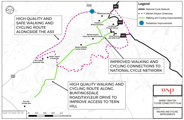
Map showing proposals for improving cycling and walking in Market Drayton
IMPROVED BUS ROUTING AND CONNECTIONS
To support enhanced public transport movements in Market Drayton and to strengthen connections to key employment sites, the following schemes have been proposed:
- Improved bus servicing to the town centre core – regular and reliable bus services.
- On demand electric hopper bus serving residential and employment sites as well as local services and amenities.
- Improved on street bus facilities – more dropped kerbs for mobility impaired users, high quality shelters and electronic boards with real-time service information for passengers at each bus stop.
- Enhanced bus station – redevelopment of the existing bus station to create an inviting and attractive public transport hub.
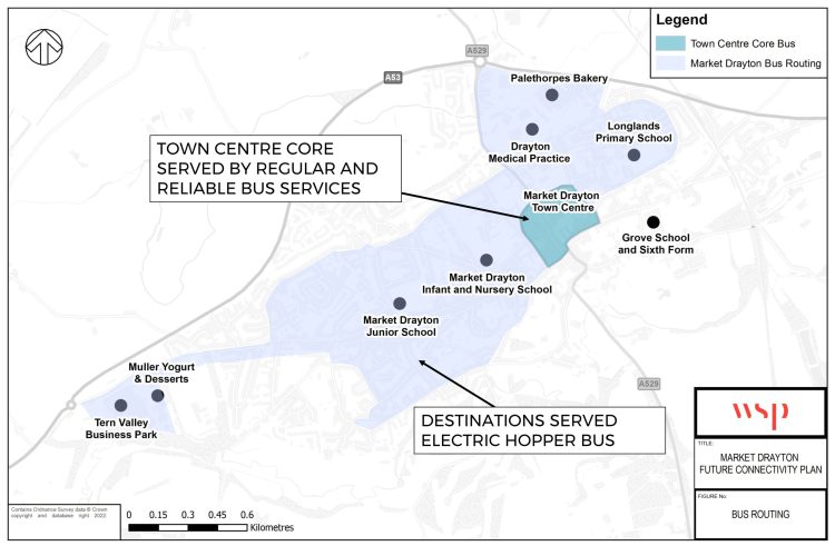
Map showing the Market Drayton bus routing proposals
SHROPSHIRE STREET/ST MARY’S STREET/HIGH STREET PUBLIC REALM IMPROVEMENTS
This scheme will deliver streetscape and public realm improvements on Shropshire Street, St Mary’s Street and High Street to deliver a high quality, attractive public environment in the town centre.
These improvements will help make the town centre a more attractive place to live, work and visit and help to support existing and new town centre businesses.
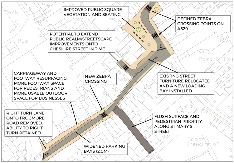
Map showing proposed improvements on Shropshire Street in Market Drayton
CHESHIRE STREET PUBLIC REALM IMPROVEMENTS
This scheme would deliver public realm and crossing improvements to support safer pedestrian movements into the town centre from Frogmore Road and the Bus Station.
The scheme would help tackle the problem that existing crossing points are not provided on the pedestrian desire line into the town centre.
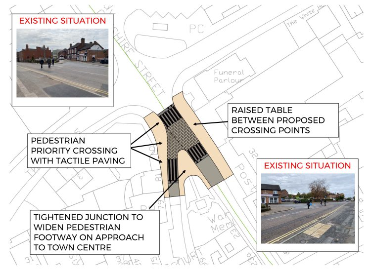
Map showing proposals for Cheshire Street and Queen Street in Market Drayton
NEWCASTLE ROAD/A53 SAFETY IMPROVEMENT SCHEME
This scheme would see a redesign of the Newcastle Road/A53 junction to enhance overall junction safety by reducing traffic speeds on the approach into the town centre, widening the pedestrian footways surrounding the junction and enhancing visibility for vehicles turning onto the A53 from the town centre.
High-res versions of the above plans/drawings can be downloaded from Shropshire Council’s Flickr.

