Local insight data tool available online
Shropshire Council has added a local insight data tool to our website. This self-serve tool enables people, organisations, businesses, town councils, parish councils and partners to access maps, profiles, reports and data dashboards.
Shropshire Council Local Insights is a web-based platform providing instant access to geographical and neighbourhood level data for areas of Shropshire, including electoral divisions, parishes, market towns, place plan areas, family hub areas and Lower Layer Super Output Areas.
Users are able to map, report and compare different data by area, and the tool provides access to a wealth of data indicators across a range of themes, eg health, population, economy, poverty and crime. This information is constantly being updated so users can be confident that you are using the most up to date data.

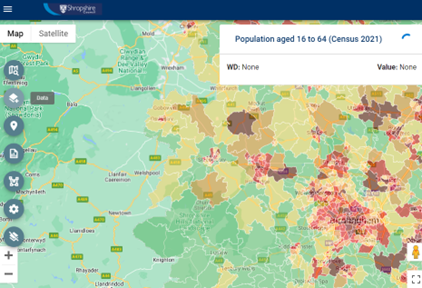
Population map on Local Insights
By providing access to this tool, organisations such as parish councils will be able to look at profiles of their own areas to help them understand the population and characteristics.
The tool has three main elements: map, reports and dashboards.
Data layers can be displayed on the map to compare rates with other areas. Services can be displayed: currently libraries, leisure centres and schools, with more to be added.
It provides comprehensive reports for divisions / wards, parishes, market towns, family hub and place plan areas. Each report contains: population, unemployment, housing, crime, health, education, employment, communities and environment, access and transport data.
You can build your own dashboard, select your preferred area, and select from the data themes.

Local Insight
Shropshire Local Insights can be viewed here Shropshire Council website with a useful “How to guide”.
For further information or assistance please contact the improvement: data analysis and intelligence team, research and performance email: businessintelligence@shropshire.gov.uk

