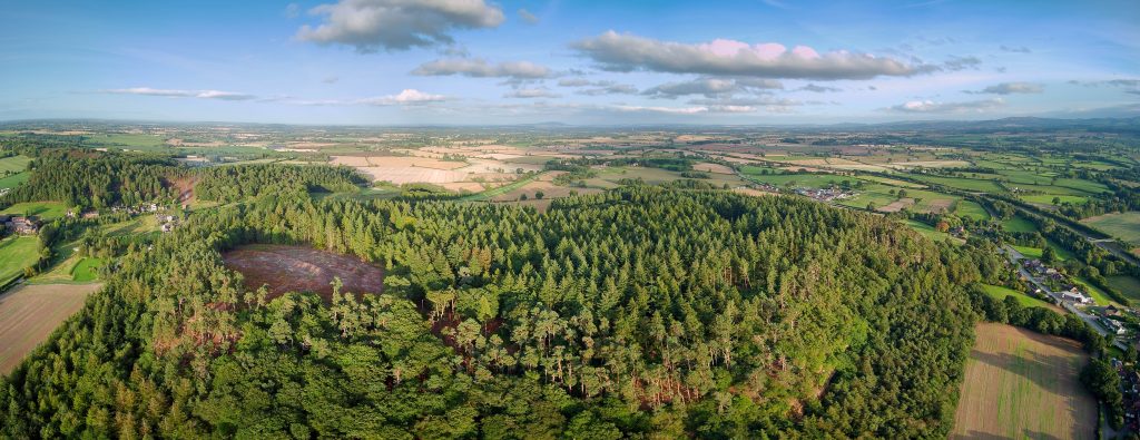
Nesscliffe Hillfort set for archaeological dig
An archaeological dig is set to take place at Nesscliffe Hillfort as we look to learn more about the history of the area.
The archaeological dig is the result of several years of previous work including habitat management, site protection measures, photographic analysis and geophysical surveys. Archaeological test pits were also dug and revealed an occupation layer with some layer of 2nd Century Roman pottery. The hillfort was probably constructed in the Iron Age, 500 BC.

Aerial shot of Nesscliffe Hillfort
This archaeological dig is believed to be the first of a hillfort in Shropshire for 40 years. It will take place from Monday 19 August to Friday 30 August 2019.
You are invited to visit the dig on Wednesday 28 August 2019 where you will be able to witness thousands of years of Shropshire history dating as far back as Iron Age and Roman times, being discovered. You will also be able to speak with the dig team to learn more about the discoveries, the site and the importance of this project. The team will be on site from 8.30am – 5.30pm.
The main aim of the dig is to help improve site interpretation for visitors and support the future management of Nesscliffe Hillfort. The project also aims to make the heritage of Shropshire available to its residents and visitors to the county.
Clare Fildes, interim head of culture and heritage at Shropshire Council, said:
“This is a hugely exciting project and follows the successful archaeological dig that recently took place at Shrewsbury Castle.
“It is important from both a management and visitor point of view that we work to better understand the history of our Country Parks and heritage sites like Nesscliffe Hillfort so we can preserve them and make them the best possible destinations for people to enjoy.
“It’s great that we are able to work with both Oxford and Southampton Universities and I’m looking forward to what the dig tells us.”
The project is a partnership between Shropshire Council’s outdoor partnerships and natural & historic environment teams and Southampton and Oxford Universities.
Gary Lock, Emeritus Professor of Archaeology at Oxford University and Co-Director of the excavation, said:
“Hillforts are one of the most impressive types of archaeological sites and yet are poorly understood. We are hoping that this excavation will help explain how Nesscliffe hillfort was built and used. It is an important and exciting project and we welcome members of the public to come and see what we are doing.”
The dig is mosaic funded with grants from The Prehistoric Society, The Robert Kiln Trust, The Society of Antiquaries and the Shropshire Archaeological and Historical Society.
1950’s excavation – Calling old diggers
Nesscliffe Hillfort was the subject of an excavation in the 1950s.
The excavations in the 1950s were carried out by staff and pupils of the Priory School for Boys, Shrewsbury. According to the report the staff were C.R. Hume and G.W. Jones. The dig team would very much like to hear from anyone who was involved in those excavations or knows anything about them. You can either visit the team onsite (19 -30 August but not Saturday 24), or contact them at gary.lock@arch.ox.ac.uk, or 07971 782788.
The small excavations in the 1950’s were carried out within the western enclosure showing evidence for the ramparts being constructed of stone and also for activity there in the Roman period.
As part of the current project, the geophysical survey within the interior has indicated the presence of roundhouses of probable Iron Age date. Test pitting has also produced Roman pottery.
Nesscliffe Hillfort is managed and maintained by Shropshire Council.
Nesscliffe Hillfort
Nesscliffe Hill Camp is a small multivallate hillfort, comprising of two conjoined enclosures, of seemingly differing dates, built against the sheer cliffs at the north-western end of the hill. The ramparts of the hillfort enclose an area of approximately 2.8ha. In its original form the hillfort appears to have consisted of a single enclosure (hereafter termed the western enclosure) encompassing the summit of the hill (Oliver’s Point) and a knoll to the east. This was defined by two ramparts, each with an outer ditch, around the southern and eastern sides, together with a single rampart with an outer ditch on the north-eastern side where the slopes are steeper. The original entrance for this phase was located at the north-eastern corner of the enclosure, between the bivallate and univallet sections of ramparts.”

